
Johnstonville Road
H&H Property.
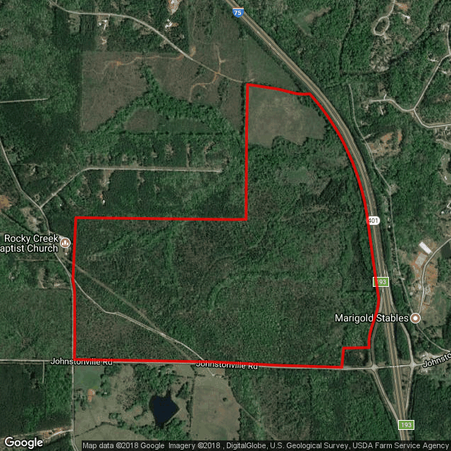
Explore a large land opportunity in the Johnstonville Road and Interstate 75 area. Start with the published location map, then work with our team to identify the current tract configuration and project fit.
Start with the location.
Let’s define the opportunity.
Johnstonville Road offers a northern Monroe County location for a project discussion. Because the older report and listing describe different acreage and rail conditions, the Authority is the right starting point for the current offering.
- Location
- Johnstonville Road / Interstate 75 area
- Current acreage
- Confirm the tract configuration with the Authority
- Published zoning
- Mixed Use
- Rail availability
- Confirm current rail access; source materials differ
- GRAD status
- Not listed as a GRAD-certified site
The existing listing described 1,650 acres and rail service, while the 2018 report described 450 acres without rail service. Current acreage and rail access need confirmation before project planning.
Start with
the service picture.
- WaterReported on site · 12-inch main
- SewerReported not on site
- Natural gasReported on site · 8-inch main
- ElectricityConfirm the provider for the specific tract
Southern Rivers Energy appears in the earlier report; the listing also names Central Georgia EMC. Confirm the service territory and capacity for the current parcel configuration.
Pricing & availability
Ask the Authority for current terms and the space or land available.
Connected to a wider region.
Approximate distances from the linked property materials.
See the setting.
Keep the details close.
Use the published maps and documents to get familiar with the property. Open plans at full size and bring your questions to our local team.
Explore the property outline.
The aerial at the top of this page opens at full size. Review it alongside the source documents below.
Earlier property report
Retained for reference; acreage and rail details differ from the later listing.
Original documents may reflect earlier conditions, contacts or incentive programs. Request current availability, terms and project requirements from the Authority.
Bring your project.
Let’s talk about the fit.
Share your land requirements, intended use and transportation needs. We’ll help you clarify which tract is being offered, the services available and the contacts for your next conversation.
Your local starting point
Development Authority
of Monroe County